INTERNET of THINGS
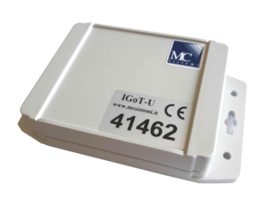
IGoT-U is an Asset Tracking system based on NarrowBand IOT technological innovation.
The GPS tracker, entirely designed and manufactured in Italy, is guaranteed to work in the most adverse operating conditions with an autonomy of 5 years.
The control of company assets takes place through the periodic transmission of the position to a multi-platform control center, capable of sending alerts in the event of an anomaly.
IGoT-U
IGoT-U is a peripheral that has been designed by combining the consolidated experience in the GNSS (Global Navigation Satellite System) field with the new NarrowBand IOT transmission technology, to identify the position of a large number of corporate assets located throughout the country.
| CARATTERISTICHE |
|---|
| The device is equipped with a GNSS (GPS – GLONASS) receiver to ensure maximum reception of satellite signals and sending the position even in the most difficult conditions of use. |
| The batteries on board guarantee a life of at least 5 years for the device, with the sending of a position per day. |
| In addition to being watertight, the protective casing is impact resistant for use in extreme work environments such as construction sites, parcel sorting terminals, warehouses, etc. |
| The IGOT-U has been designed with the possibility of integrating a motion sensor and, on request, it can be customized with sensors for the detection of external environmental conditions (e.g. temperature, volume, weight sensor etc.) |
| It is possible to awaken the equipment manually by placing a magnet on the MC logo for a few seconds, thus allowing the sending of the data detected at that exact moment. This type of operation can be carried out during the check of the equipment or at the end of the installation of the equipment. |


Web Tracker
![]()
Web Tracker is the multi-user platform for managing satellite localization and controlling IGoT-U peripherals, accessible via PC or mobile terminal (smartphone, tablet) connected to the Internet. Through this platform it is possible to view on a digital map
(Google or Bing) the location of all peripherals in use, accompanied by the relevant operational information.
It is also possible to produce reports with the position data of the devices, as well as view the historical data of the journey. Any anomalies in the functioning of the peripherals generate alarms which are followed by the receipt of an informative e-mail.
